The results of the national external transportation direction survey are used for planning and investment in road management mainly for the construction of city bypasses in ideal localization on the main transportation routes. Relevant knowledge of transport directions can optimize the impact of the outer traffic on the inner city traffic.
In 2007, SSC realized a transportation direction survey in selected towns with over 5000 inhabitants in the vicinity of the motorways, I.class and II.class roads with preference of the towns located on the main routes of the European road network „E“.
The national research was realized
on Thursday 20th September 2007.
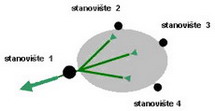
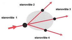
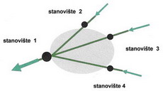
Observation stations in selected towns are displayed in the section about parcial results for each town in appended scetch of the town.
The outer traffic research was conducted by registering a registration number of the vehicle concerned.
The survey enables to observe:
- direction of the travel of vehicle
- type of travel in relation to the town ( Z - source, C - destination, T - transit )
- intensity of various types of vehicles ( O – passenger vehicles, N – cargo and busses)
Traffic which enters and leaves town in 15 to 30 minutes is considered transit traffic.
The comparisson of the 2005 external traffic census with the 2007 external traffic census is solely indicative as the census zones are not identical.
The survey results for selected towns are presented in the territorial breakdown of the Slovak republic in self-overning regions with following content:
-
Profile intensity of average daily intensity of traffic (PDI) on the frontier between the rural area and the residential area according the type of vehicle
-
maximum values of external transport traffic reached within a day of traffic research based on the travel type of vehicle respective of the town (Z, C, T) and irrespective of the town (S).
-
total number of vehicles (PDI) based on the travel type respective of the town
-
total number of vehicles (PDI) in transit transport direction
-
Percentage of vehicles in relation to the evidence number in respective district, neighbouring districts and other territory.
Notes:
PDI - average daily intensity of traffic
- CSD year 2007- assumed daily traffic intensity in real numbers of vehicles per day specified by the national traffic census from 2005 and the projection coefficients of intensity growth by 2007
- direction flow research 2007 – the average daily traffic intensity in real numbers of vehicles per day defined by direction flow of external traffic survey in selected towns in 2007
O – passenger transportation in real vehicles per day
N – freight and bus transportation in real vehicles per day
S – total transportation ( O+N) in real vehicles per day
Z - source transportation in real vehicles per day
C - destination transportation in real vehicles per day
T – transit transportation in real vehicles per day
Travel type of vehicle:
-
source journey – the vehicle travel started in residential area of surveyed town and continued outside the town
-
destination travel – the vehicle travel started outside the town and finished in the residential area

-
• transit travel – the vehicle travel started outside the residential area and continued in travel to rural area
entry of the station to individual stations
exit of the station from individual stations
Map of census stations [JPG, 700 kB]
The results of the national census of traffic direction in SR in 2007 in breakdown by self-governing regions:
Updated: 16.5.2016
Published: 15.12.2008